Student Research
2005
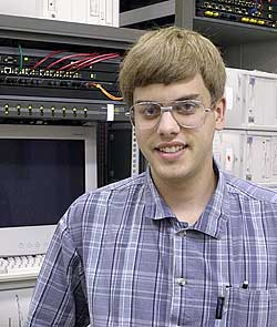
Ben Estes (senior health physics major) constructed a Beowulf cluster. I use the cluster to generate 3D shape models of asteroids from their radar images. Although not my advisee, his work is so good I wanted to include a link to show you this work.
2004
Joshua Schlieder (senior physics major) investigated the near-Earth asteroid 2002 CE26 from radar observations he and Dr. Shepard acquired at Arecibo Observatory (Puerto Rico) in August/Sept 2004. Josh presented a poster with some of his preliminary work at the American Astronomical Society's Division for Planetary Sciences meeting in Louisville, KY in November. abstract
 At Arecibo Observatory.
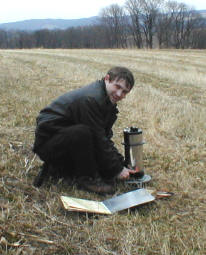
Christopher Guise conducted a gravity survey of a large buried valley (former channel of the Susquehanna) near Mainville. His work showed that as much as 50-70m of glacial till now fills the valley, and is consistent with the few wells in the area and previous seismic work nearby.
2003
Jim Street completed a senior research thesis entitled "Focused Earthshine as a Source of Ashen Light". Jim was also awarded the 2003 Outstanding Geoscience Senior Award. Jim and his wife Christina have a new baby boy (Daniel) and live in Lancaster where he teaches science at a local middle school.
2002
Elaine Gustus's Senior Thesis was entitled "Investigation of a Buried Valley at Lackawanna State Park, Pennsylvania. Dr. Braun co-advised. Geomorphic landforms suggested that a valley in Lackawanna State Park had been buried by glacial till in the Wisconsin retreat. Elaine used seismic refraction profiling to look for this hypothesized valley. While she did not find a till/bedrock interface, the depth of till strongly supports the hypothesis, and she was able to place lower limits on the depth of till covering the valley.
Update (2004): Elaine is now working for a geophysical consulting firm.
Scott Krauss also conducted a geophysical study to locate another hypothetical valley at Salt Spring State Park. In this case, Scott found solid evidence for a bedrock valley floor some 20-30m beneath the surface. Dr. Braun was his co-advisor.
Amy Bruggeman (staff geophysicist at ARM Group, Inc. and alumna '01) illustrates a magnetic anomaly detector to the '02 geophysics class. Shown are (right to left) Elaine Gustus, Scott Krauss, Amy Bruggeman, and Jim Street.
2001
Amy Bruggeman's Senior Thesis was entitled "A Geophysical Examination of the Delaware Valley at Skinners Falls. Dr. Duane Braun co-advised. In essence, Amy used seismic refraction profiling to look for and find a hypothesized buried valley near a falls on the Delaware River. A highlight of this research was meeting the field area's landowner, John McPhee. He is the author of many books including geological and environmental works such as Basin and Range, In Suspect Terrain, and The Control of Nature. Amy has since taken a position with a geo-technical consulting firm.
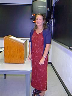
Amy presenting her senior research project.
2000
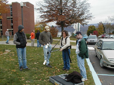
Ryan Steigerwalt's Senior Thesis examines the small islands in the Susquehanna River and addresses the hypothesis that these islands are collections of sediment and vegetation around "knobs" or other topographic highs in the river channel. Using seismic refraction profiling, he determined that these islands are sediment all the way to the river bottom, i.e., there are no knobs or other asperities acting as accretion points. The islands are therefore probably temporal features and are currently held in place by abundant vegetation.
Ryan generates seismic waves by hitting a metal plate.
Alicia Musselman used seismic refraction techniques to look for the Light Street Fault in the old landfill in Mount Pleasant Township. Her seismic records found unusual features some 5-10m below the surface which are consistent with the predicted location of the fault zone.
Darrick Kreischer used Viking and Mars Orbiter images of the surface of Mars, along with published engineering constraints, to propose several landing sites for the (now cancelled) Mars 2001 lander. His proposed landing sites are similar (and in some cases identical) to those being considered for the Mars Explorer Rover 2003 mission.
Julius Armstrong, III completed a full-time internship at the PPL Montour preserve. Among his activities were giving (and in many cases, developing) presentations on maple sugaring, birds-of-prey, wildflowers, fossil-identification, owls and owl-pellet dissection, among others. His primary task was to develop a planet-walk for the preserve. A planet-walk is a true-scale model of the solar system. You begin at the sun and walk to each of the planets, where a scale model or picture of the planet is presented, along with information about that planet. The distance between the planets is at the same scale as the planet size. Most people are shocked when they walk hundreds of yards to reach Pluto, and it's smaller than a grain of sand!
Julius is now working on a Masters at Embry-Riddle University.
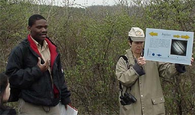
Julius giving a presentation on the Planet-Walk tour he developed.
1999
Zachary Musselman (no relation to Alicia, above) completed several projects with me. During the summer of 1998, he worked on "Geomorphology from Space - Radar", an HTML based program of various geomorphic landforms observed in radar wavelengths. He downloaded images from the Jet Propulsion Laboratory's Shuttle Imaging Radar website and scaled and rotated them to be consistent with images from the book "Geomorphology from Space" by N. Short. The result is many pairs of images, taken by optical satellites (Landsat Thematic Mapper primarily) and the Shuttle Imaging Radar. I conceived of this as a way to illustrate differences between visible light and radar images when looking at the same terrain.
For his Senior Research Thesis, Zach tested a common super-resolution algorithm used by many to improve image quality in spacecraft lander images. The test involved using a digital camera to take many similar images of a test pattern and co-add the images in a prescribed way to improve the image quality. These derived image products were tested to determine if the resolution of the final product was better than any individual image. In fact, he found the images were improved, but the resolution was not. In essence, it appears that co-adding the images only improves the signal-to-noise of the final image without improving the resolving power of the camera (or resolution of the final image). These results were presented at the 30th Lunar and Planetary Science Conference in Houston, in March of 1999 (see the citation in my vitae).
For his Honor's thesis (no, we're not through yet!), Zach took telescopic images of the asteroid 4 Vesta using a small telescope and CCD camera borrowed from the Department of Physics. Approximately 3 hrs of images were acquired, one every 10 minutes or so, to see if a discernible change in the brightness occurred. Vesta rotates once every 5.3 hours. Ideally, he would have obtained images over 5-8 continuous hours, but the weather conspired against him. Nevertheless, there was a discernible change in the brightness over the observing period consistent with the known rotation period.
Zach obtained a Master's degree at Texas Christian University in December 2001. His thesis was entitled "Morphometric and Areal properties of Alluvial Fans associated with Rosillos Mountains, Brewster County, and Big Bend National Park". He is now a Ph.D. candidate at the University of Kentucky.